TL;DR: blindly follow the short-term snow-conditions forecasts from Whistler-area weather expert @powderpicker; they’re usually posted ahead of powder days.
Say it three times because it matters:
The point of weather forecasting is reading the trend‼️
The point of weather forecasting is reading the trend‼️
The point of weather forecasting is reading the trend‼️
What’s truly valuable is the trend of how storm systems move—not the quantitative numbers a model outputs, like temperature, snowfall totals, or the exact height of the snowline (freezing level). Those figures look intuitive, but in the complex environment of coastal mountains, they’re essentially an irreversible loss of information and can easily mislead you.
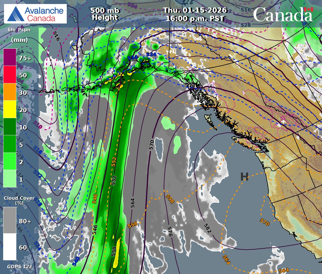
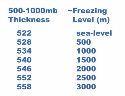
Take the snowline as an example: it’s only an indicator reflecting changes in air-mass structure. What matters is the direction and speed at which cold and warm air advances, not the snowline number at a specific moment. A genuinely effective way to read the snowline is to use Avalanche Canada’s weather charts to understand the overall evolution of the meteorological system: by rule of thumb, the 500–1000 mb thickness has a direct correspondence with the snowline. If you see the yellow dashed 546 line pushing significantly north and crossing Whistler, it means you can take the day off at home.
Another key to reading weather charts is understanding how snowfall forms in the PNW: it largely depends on how low-pressure systems over the Pacific organize airflow from different directions. A mature coastal low will draw warm, moist subtropical vapor from the south, while also pulling in dry, cold polar air from the north or inland. These opposing air masses are forced upward and stacked over the coastal mountains, ultimately determining snow quality. Warm, moist flow from the south often brings denser, higher-water-content snow; and only when northern polar cold air drops south and overlaps with ocean moisture does Whistler get truly light “champagne powder”—and the riding experience between the two is completely different.
The RWDI Synopsis on Peak Live is another relatively accurate source. Its background is professional meteorological support for infrastructure services, and it’s often more reliable for short-term trend judgment. When the weather gurus are busy chasing pow and the video hasn’t been updated yet, this can be your primary reference. But note: it is not the same thing as the weather forecast on the Whistler resort website—the latter’s positioning makes its accuracy similarly close to a “scam.”
To further understand why model forecasts are inaccurate, you can’t avoid the issue of resolution. It refers to the smallest scale at which the grid used for numerical simulation can represent terrain and atmospheric structure; typical horizontal resolution is around 9–25 km. That means, in a model’s eyes, Whistler’s complex valley-and-ridge terrain is simplified and averaged into a few smooth undulations. In reality, once a storm system enters a coastal alpine environment, it undergoes complex orographic lift, flow turning, and local enhancement; actual snowfall is hard to summarize with a single precise number. The result is that models can often predict that a storm system will arrive, but struggle to precisely describe where the snow will fall, what form it will take, and exactly how much will fall.
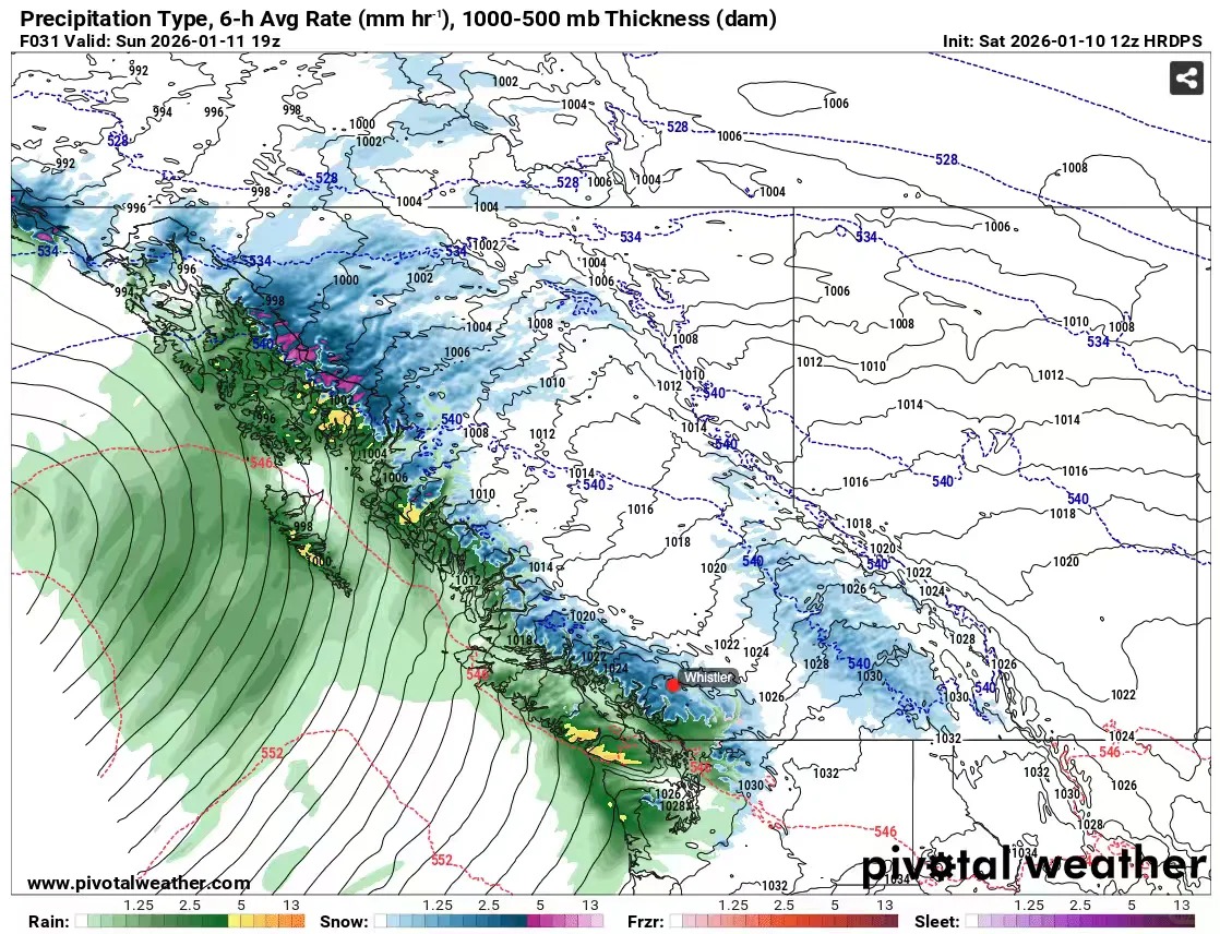
Therefore, even for a high-resolution model like HRDPS at 2.5 km, the practical, experience-based approach is to cut the forecast snowfall totals in half first, and then combine that with real-time temperature and wind-speed sensor readings to judge how fast cold/warm air masses are moving in. Because for determining the final snow conditions, models are far less reliable than sensors. And sites like Snow-Forecast—anything beyond a three-day forecast is basically a scam. When its model tells you “80 cm in the next five days,” it’s essentially an extremely unstable hallucination. Snow in the model is always imaginary; only what ends up on the snow ruler is real.
Once you start referencing multiple models at the same time, you’ll run into the concept of “model convergence.” Because models differ in numerical algorithms, initial fields, and the observations used for blending and assimilation, they often diverge significantly in medium- to long-range forecasts—an intuitive manifestation of chaos—usually meaning the storm track, intensity, or snowfall distribution is still highly uncertain. Only when multiple models gradually converge on timing, the position of precipitation bands, and temperature trends does it mean this powder day is truly “locked in.” By combining multiple models into an experience-based multi-expert system, you’ll develop a more intuitive sense of forecast credibility—only when you see model data converging is it worth genuinely looking forward to.
On powder days, getting the timing right is crucial. If snowfall happens overnight, charging the rope drop the next day is the obvious choice. But if the main snowfall is expected during the day, then the time distribution of snowfall intensity, and whether wind speeds allow the alpine lifts to open, become the key factors in deciding whether to go up: a wrong call might leave you scraping ice in driving wind and snow, or lying in bed and regretting it while doomscrolling face-shot pow posts in your feed. In short-term forecasts, the storm cycle usually won’t be delayed by much, but in the Whistler area, in my experience, it’s not uncommon for storms to finish dumping earlier than expected. In those moments you often have to gamble a bit—pow is ultimately up to fate; worst case, you just don’t ride and have a drink at the top, which is still a pretty pleasant experience.
Finally, skiers and riders who are new to big mountains often underestimate how much wind speed and direction affect alpine snow conditions. The wind load effect can quickly build up on certain aspects—just over ten centimeters of new snow can deliver a bottomless deep-pow experience—while other areas get scoured into ice. On steep terrain right after a storm you might get face-shot cold smoke, but under wind action, new snow also goes through a settlement process, becoming denser but with better buoyancy, and actually offering advantages in stability/consistency and travel efficiency. Understanding these processes helps you judge where you need to charge immediately, and where it’s better to wait.
To sum up: although “certification levels” are especially popular in the snow world these days, the riding technique that CASI or CSIA can teach you is only a small part of the overall skiing knowledge system. If you’re lucky enough to be based in a big-mountain place like Whistler, what’s truly worth investing more energy in is another, more important thing: how to read the mountain.